Through satellite images and deforestation alerts made available with open access to the Dashboard, monitoring changes in the vegetation cover of the 03 Biomes of the State is shared with society with transparency.
SCCON Geospatial, a Brazilian technology company in the Geospatial segment, launches a new version of the Vegetation Cover Monitoring platform used by the Mato Grosso State Environment Secretariat (SEMA-MT). Updating the Dashboard provides easy public access to deforestation alerts and other changes in native vegetation, such as exploration, degradation, fires and illegal appropriation.
The tool makes it possible to analyze maps, data and graphics on the situation of native forests in Mato Grosso. The Vegetal Coverage Monitoring System uses Planet Scope constellation technology, with more than 130 satellites that daily capture high spatial resolution images, providing users with access to more accurate and up-to-date information.
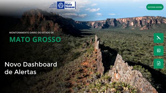
Figure 1. Project home page
Access to information
According to Iara Musse Felix, SCCON CEO, the geospatial monitoring system was contracted in 2019, renewed in 2020 and has significantly contributed, in an operational way, to the control and inspection strategies and actions by the technical and management teams of SEMA and other institutions which, together with SEMA, has made a difference to the results regarding the fight against illegal deforestation in the state of Mato Grosso. Now, with the changes made, the new dashboard is more intuitive, in addition to bringing auxiliary functions that allow users to carry out a weekly quantitative and qualitative analysis of the status of monitored areas. A highlight is the transparency that monitoring provides, since anyone can enter the portal and have access to the data, bringing citizens closer to actions in relation to environmental conservation in the State of Mato Grosso”.
With the platform, change alerts for the entire territory of Mato Grosso, which covers a total of 903,000 km², are processed and made available on the Web Dashboard. And, through the available filters, it is possible to verify changes in vegetation in different areas, in addition to allowing the user to define specific time intervals for the analyses.
Identification of fires and deforestation
Users can also identify interference captured by satellite images, according to the type of removal such as clear cut, degradation or burn scar. Consulting the alerts on the dashboard can also be combined with data from the Rural Environmental Registry of Mato Grosso (CAR-MT), allowing the identification of rural properties where the alerts are located, as well as analyzing the dynamics of the rural property with the Planet images available.
Platform History
SEMA-MT already has the SCCON Platform for monitoring vegetation cover and generating alerts since 2019, the tool was contracted by the REM Program, through the Brazilian Fund for Biodiversity (FUNBIO), with resources from Germany and the United Kingdom .
The implementation of the SCCON platform improved the analytical capacity of Sema managers, optimizing the monitoring, inspection, control and management processes for the direct fight against illegal deforestation. Proof of this is the significant reduction in the increase in the State's deforestation rate after the implementation of the project, which fell from 14.2%, between the 2018-2019 period, to 3.8%, between the years 2019-2020, according to official data of PRODES 2021.
See below some Dashboard screens
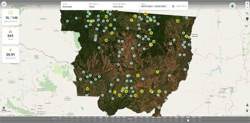
Dashboard screen containing clusters of deforestation alerts occurred between 01/04 and 02/03/2021.
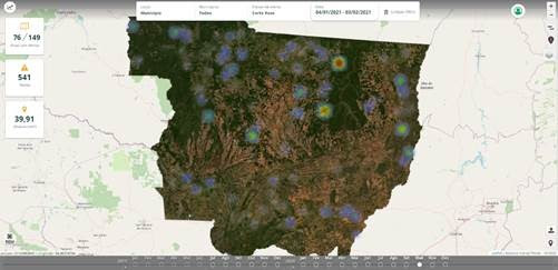
Dashboard screen with alert heat map (greater deforestation pressure) between 01/04 and 02/03/2021
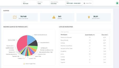
Dashboard screen with graphics and management information regarding deforestation that occurred between 01/04 and 02/03/2021.
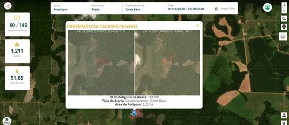
Preview image of before and after an occurrence of removal of native vegetation.